Monte Alban and the Zapotec Cities of Oaxaca: A Two-Day Guide
Most people book Oaxaca for the food. The mole, the mezcal, the Saturday sprawl of the Central de Abastos, tlayudas eaten standing up at midnight. Almost nobody books it for the archaeology, which is odd, because a 2,500-year-old capital city sits on a levelled mountaintop twenty minutes uphill from the zocalo, and the valley below holds one of the densest concentrations of pre-Hispanic sites anywhere in Mexico.
Monte Alban and the historic centre of Oaxaca were inscribed on the UNESCO World Heritage List together in 1987, under four of the convention’s cultural criteria. The pairing is deliberate. The listing treats the Zapotec mountain city and the Spanish colonial grid below it as two chapters of the same place rather than two attractions that happen to share a postcode. (If the criteria numbering means nothing to you, our guide to how the World Heritage List actually works unpacks it.)
The city that levelled a mountain
Monte Alban was founded around 500 BC on a ridge roughly 400 metres above the valley floor, at about 1,940 metres above sea level. The founders did something that still takes a moment to absorb when you are standing on it: they cut the top off the mountain. The Great Plaza, about 300 by 150 metres, is an artificial surface, quarried and filled and flattened by hand. The pyramids around its edge are partly made of what came off it.
Why put a capital on a waterless hilltop with no farmland? The leading answer is political. Monte Alban sits at the junction of the three arms of the Valley of Oaxaca, visible from all of them and belonging to none. It reads as a deliberately neutral capital, founded at the moment the valley’s competing chiefdoms consolidated into a state. By the end of the Formative period something like 17,000 people lived on the mountain and its terraces.
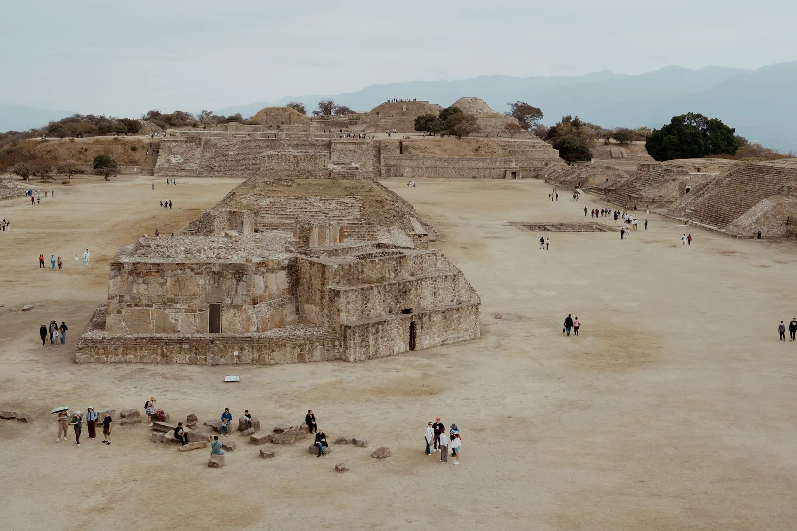
Influence drained away between roughly AD 500 and 750, and the city was largely empty between 900 and 1000. Nobody has settled on a single cause. Drought, the collapse of Teotihuacan’s trade networks to the north, and the rise of rival valley towns all appear in the literature. The honest position is that the argument is still open.
Reading the stones
Two things on the plaza are worth slowing down for.
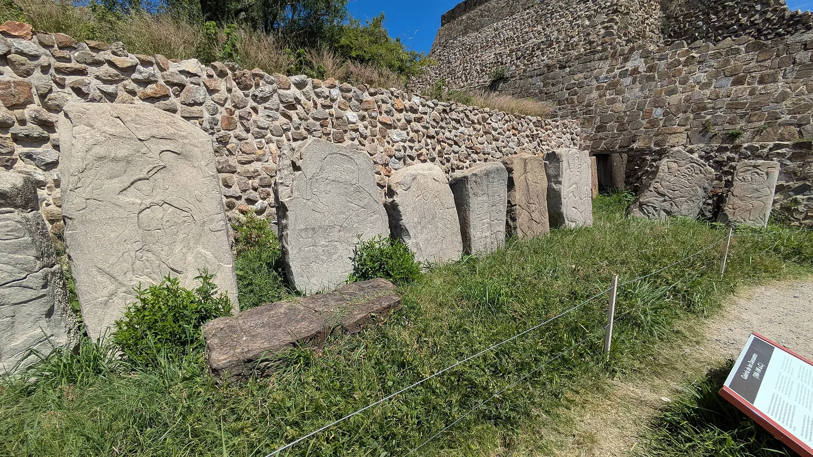
The Danzantes are a gallery of carved slabs along the plaza’s western side, more than 300 of them documented. The name means “dancers”, which is what nineteenth-century visitors assumed the contorted figures were doing. They are almost certainly not dancing. The current reading is that they show tortured and sacrificed war captives, several identified by name in accompanying glyphs, displayed as a permanent notice of what happened to the losers. Some of those glyphs are among the earliest writing in Mesoamerica. Capitals have a habit of inventing script at exactly the point they start keeping records of conquest, which is also what the oracle bones do at Yin Xu in our route through ancient China.
Building J, the arrow-shaped oddity set at a skew to everything else, carries more than forty carved slabs usually read as a list of conquered places. Its strange orientation has fed a long argument about astronomical alignment, including a proposed sightline to the heliacal rising of the star Capella. Treat that as a supported hypothesis, not a fact. Guides tend to state it with more confidence than the evidence carries.
Note what is not there, too. The slabs standing in the Danzantes gallery today are replicas. The originals are protected in the site museum and in Mexico City, which is a pattern you should get used to in Oaxaca.
Tomb 7, and why the museum comes first
On 9 January 1932, Alfonso Caso tunnelled into an unremarkable tomb near the site’s northern edge and found the richest burial ever excavated in the Americas. Tomb 7 held more than 500 objects: about 3.6 kg of worked gold across 121 pieces, silver, turquoise mosaic, rock crystal, obsidian, jade and carved jaguar bone.
The twist is that the treasure is not Zapotec. The tomb is a Classic-period Zapotec structure, but the burial inside it is Mixtec, placed there centuries after Monte Alban had been abandoned. Mixtec elites moving into the valley reopened an ancestral Zapotec tomb and reused it as a shrine for their own dead, which tells you a good deal about how they wanted to be seen.
Almost none of it is on the mountain. The bulk sits in the Museo de las Culturas de Oaxaca, in the former convent of Santo Domingo de Guzman in the city centre, with selected masterpieces in the National Museum of Anthropology in Mexico City. Go to the museum before you go up the hill, not after. The same logic that makes Heraklion the right first stop on a Crete palace itinerary applies here: the ruins are just geometry until you have seen what came out of them. The museum opens Tuesday to Sunday, roughly 10:00 to 18:15, and closes Mondays. Admission runs around 75 pesos.
Mitla and the mosaic nobody repeated
About 45 km southeast, in the Tlacolula arm of the valley, Mitla is the opposite kind of site. Where Monte Alban is mass and elevation, Mitla is surface. Its palace facades are sheathed in grecas, geometric fretwork assembled from thousands of small cut stones fitted dry, without mortar. By most accounts no design in the complex is repeated exactly.
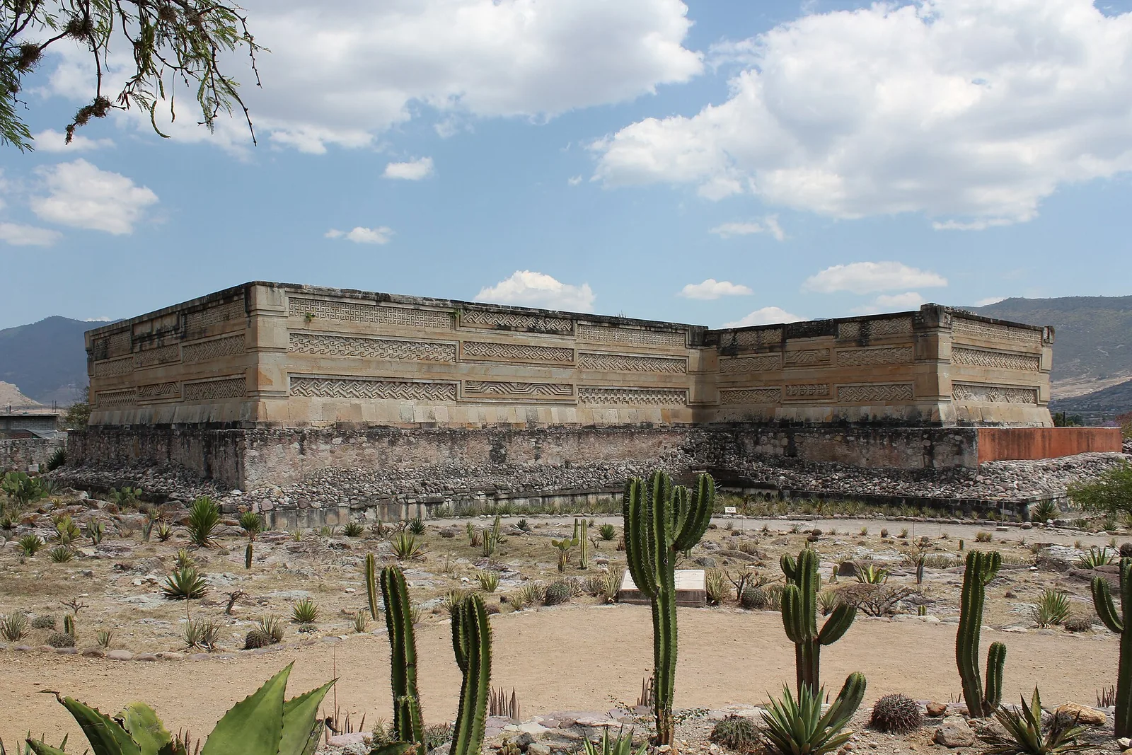
The technique deserves a moment. It is the precise inverse of the Roman answer to the same problem, where the mortar itself did the structural work. At Mitla there is no mortar and the accuracy of the cut carries everything. In a seismically active state, that dry fit has held for centuries.
Mitla became the Zapotec religious capital as Monte Alban faded, and it stayed in use up to the conquest. The Nahuatl name comes from Mictlan, “place of the dead”. The Zapotec name, Lyobaa, means “place of rest”. Of five building groups, the Columns Group and the Church Group are the two you actually visit. The Spanish planted the church of San Pablo directly on top of the latter in the sixteenth century, theology expressed in masonry.
Colonial accounts describe a great subterranean temple beneath the site, an entrance to the underworld, sealed off by the church. Between 2022 and 2024 the Lyobaa Project, working with INAH and UNAM, ran three geophysical methods over the ground (ground-penetrating radar, electrical resistivity tomography and seismic noise tomography) and mapped a void roughly 15 by 10 metres at a depth of about 5 to 6 metres beneath the church, with passages running off it. Nothing has been opened. There is currently nothing to see down there, which does not make standing on top of it any less interesting.
The quiet three: Yagul, Atzompa and Dainzu
Yagul is the best of the three and the most skipped: a fortress and palace complex on a rocky spur above the Tlacolula valley, with a large ball court and a hilltop citadel worth the climb for the view. It also forms part of a second, separate UNESCO listing, the Prehistoric Caves of Yagul and Mitla, inscribed in 2010 for the rock shelters on the slopes above. One of them, Guila Naquitz, produced 10,000-year-old squash seeds and the earliest documented maize cobs on the continent. The caves are not really visitable, but knowing that plant domestication in the Americas begins on the hillside in front of you changes the view considerably.
Atzompa occupies the ridge just north of Monte Alban and was part of the same city. It has three ball courts, one of them about 45 metres long, bigger than anything at Monte Alban itself. Entry is free.
Dainzu, nearer the city, is small and frequently deserted, and earns the stop for one thing: a set of carved reliefs showing ball players in gloves and feline masks, in a style you will not meet elsewhere in the valley.
A two-day loop from Oaxaca city
Day one, the mountain. Museo de las Culturas at Santo Domingo when it opens, then up to Monte Alban for the afternoon. Or invert it: Monte Alban at 08:00 for cool air and an almost empty plaza, museum afterwards. Tourist shuttles run from the city centre several times a day and a taxi takes about 20 minutes. Add Atzompa if you have your own vehicle.
Day two, the Tlacolula valley. Everything lies along Highway 190, so you can do Dainzu, then Yagul, then Mitla at the far end. Colectivos and second-class buses toward Mitla leave frequently from the Central de Abastos area, cost roughly 25 to 50 pesos, and take a little over an hour. Ask the driver to drop you off at the Dainzu or Yagul turnoff and walk in, since both sit back from the highway. Make it a Sunday and you can fold in the Tlacolula market, which is a genuinely great one.
Altitude, heat and practical details
Oaxaca city sits at about 1,555 metres and Monte Alban at 1,940. That is not Cusco, but if you flew in from sea level yesterday you will notice the plaza. Take the pyramid stairs slowly.
There is essentially no shade up there. Hat, sunscreen, and more water than you think you need. Monte Alban and Mitla both run 08:00 to 17:00 with last entry around 16:00. Admission at both is 210 pesos for foreign visitors and 105 for Mexican nationals and residents with ID, free on Sundays for nationals and residents. Atzompa is free, Dainzu and Yagul cost less. INAH adjusted several of its fees in 2026, so confirm current prices before you go.
Accessibility deserves a straight answer. The Great Plaza itself is broad and level, and a wheelchair user can genuinely experience it. However, the approach involves a slope, and every pyramid, the Danzantes gallery and most of Mitla involve steps and uneven stone. The site museums and Santo Domingo are the most manageable stops.
The stone that ties it together
One last thread. In June 2026 the International Union of Geological Sciences designated Oaxaca’s cantera verde, the bluish-green volcanic tuff that turns vivid after rain, as a global “geoheritage stone”. It is the stone of Santo Domingo, begun in 1575, and of half the facades in the historic centre. The original quarries are now built over and closed.
It makes a neat coda for the two-day loop. The Zapotecs cut a mountain flat and faced it in stone. The Spanish quarried the same volcanic valley and laid out a grid city from it. Walk the plaza in the morning and the green tuff arcades in the evening, and you are reading one long argument about what to do with a mountain.
Further reading (sources)
- UNESCO World Heritage Centre on the 1987 Oaxaca and Monte Alban inscription record
- UNESCO World Heritage Centre for the separate listing covering the Yagul and Mitla caves
- Instituto Nacional de Antropologia e Historia with the official visitor page for the Monte Alban zone
- Smithsonian Magazine on the chambers mapped beneath Mitla’s colonial church
- ARX Project for the geophysical survey seasons at Lyobaa
- National Geographic with a close look at the gold pectoral from Tomb 7
- The Art Newspaper on green tuff and its geoheritage designation
Feature Photo by nsaum75 !Dígame¡ , CC BY-SA 3.0, via Wikimedia Commons.